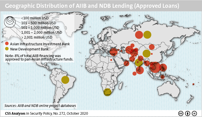
This week’s featured graphic maps key maritime oil chokepoints and daily volumes. For more on the Geostrategic Storm in the Indian Ocean read Boas Lieberherr’s CSS Analysis in Security Policy here.
Tag: China
This graphic maps the countries located in the Arctic Circle, as well as its passages and sea routes. In the Arctic, Russia and China have their own ambitions, but their objectives currently overlap. Complementary economic interests are the main driver of their cooperation.
For more on the Sino-Russian dynamics in the Arctic, read Maria Shagina and Benno Zogg’s CSS Analysis in Security Policy here.
This week’s featured graphic maps Southeast Asia in the area of tension. For more on China-US rivalry in Southeast Asia, read Linda Maduz and Simon Stocker’s CSS Analyses in Security Policy here.
This week’s featured graphic maps the Belt and Road Initiative (BRI) in Europe as of December 2019. To find out more, click here to read this Strategic Trends 2020 chapter by Henrik Larsen and Linda Maduz on how China’s growing influence in Europe has the potential to create new geoeconomic divides.
China’s Belt and Road Initiative (BRI) has both a land-based and a maritime component. This graphic provides an overview of the maritime element, the Maritime Silk Road Initiative (MSRI) which connects China to Europe and Africa via the Middle East. For an insight into the BRI in the Middle East, including its implications for China’s impact on the region, read Lisa Watanabe’s CSS Analyses in Security Policy here.