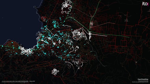
Accurate and timely maps are a vital resource in contemporary disaster and crisis management. Maps are essential for identifying vulnerabilities, monitoring the effects of disasters and organizing countermeasures. Traditionally, the mapping of crises was the exclusive domain of experts, including cartographers and crisis management professionals. But with the growing democratization of information and communications technology, this monopoly is disappearing.
Recent disasters have witnessed a new generation of online maps, created by civil society actors and relying on volunteers to collect, organize, verify, visualize and share geo-referenced information. Prominent examples include the crowdsourced maps created in the aftermath of the Haitian earthquake in 2010 and during Hurricane Sandy in 2012. Although these mapping projects differed in many respects, they had a common aim – to aggregate geo-referenced information from a large number of sources in order to make that information useful for emergency managers as well as those affected by the crisis.
Depending on the demands of the situation, crisis mapping can fulfill various functions. For example, a crisis map can involve collecting and organizing information from an affected area in order to improve the situational awareness of emergency responders. Crisis mapping can also be used to filter and categorize information from other sources (such as social media, which has proven to be an important means of communication during several recent disasters), allowing crisis managers to implement more effective countermeasures.
In the past, governments have regarded crowdsourced crisis mapping with skepticism and concern because of the negative impact they feared it could have on established crisis management and communication efforts. More recently, governments have become more receptive to crowdsourced approaches, in recognition of their usefulness in mitigating the effects of disasters and speeding up recovery processes. Nevertheless, little remains known about how crisis mapping can be integrated with established disaster management procedures. As I have argued in a recent study on the topic (co-authored with Jennifer Giroux and Michel Herzog), a positive step would be to strengthen relationships between the various actors involved, including public authorities, private enterprises and civil society groups, to facilitate coordinated responses to disasters.
“Swiss Crisis Mapping” at the Center for Security Studies
To help make this a reality, the Center for Security Studies (CSS) recently conducted an expert workshop on crisis mapping, together with the Swiss Federal Office for Civil Protection and the Institute of Geomatics Engineering at the University of Applied Sciences and Arts Northwestern Switzerland. The workshop brought together a variety of stakeholders, including geo-specialists, media professionals, civil protection officials and other experts in the field, to participate in an open dialogue.
As geo-information expert Hans-Jörg Stark explained in his opening presentation, crisis mapping is still a very young and dynamic phenomenon. As he pointed out, it was only made possible by the rapid spread of mobile communication technologies, increased internet bandwidth and widespread access to global satellite navigation information and geo-data in recent years. According to Mr. Stark, one of the main challenges in the field of crisis mapping is enhancing mutual understanding among stakeholders. This could be done, he concluded, with the establishment of new networks, connecting key national and international actors in the field. At the same time, on the technical side, applications and interfaces for the creation of situation-tailored crisis maps needed to be developed further.
Listen to an interview with Mr. Stark:
Over the course of the day, a fruitful and lively exchange of perspectives took place. Peter Buri from Canton Thurgau, for example, provided the perspective of a cantonal disaster and crisis management organization. As Mr. Buri explains, establishing common standards across different levels of government for new information and communications technologies is a serious challenge, especially in a federal system like Switzerland. He suggests that crisis management organizations can overcome it by building experience in this new domain, initially by engaging with social media during small-scale emergencies. In another presentation, journalist Julian Schmidli discussed possible roles for the ‘traditional’ media in crisis mapping, suggesting that well-connected media outlets could moderate and facilitate crisis mapping efforts. Mr. Schmidli also pointed to some of the challenges that could hamper efforts. In particular, he stressed that mutual trust would be vital for any successful collaboration in this area. The day concluded with a scenario exercise, in which the participants could gain hands-on experience with the creation and management of a crisis mapping platform.
Listen to an interview with Mr. Buri:
Listen to an interview with Mr. Schmidli:
As the workshop illustrated, realizing the potential of crowdsourced crisis mapping for professional disaster and crisis management remains a challenge on many levels. In addition to technical problems such as inadequate data standards and interfaces, there are legal issues that need to be clarified – over the use of proprietary geo-information, for example. Established institutional routines and identities are also an obstacle, as they often resist new forms of collaboration. Since crisis mapping is still quite a new phenomenon, mutual understanding still needs to be established. And as the workshop revealed, there is still no consensus about fundamental issues such as ‘what crisis mapping is’ or what its main purposes are.
Ultimately, however, equitable partnerships between authorities and other social actors are likely to gain importance over time. These collaborations do not have to undermine the responsibilities of disaster management authorities. Instead, they can aid officials in effectively fulfilling their mandates. This means that governments should take proactive steps to overcome existing cleavages and develop a broad range of new partnerships – between private business, academia and civil society – to deliver better maps for future crises.
Florian Roth is a researcher at the Center for Security Studies. He studied Political Science, History, Arts and Media at the University of Konstanz. His research interests include security risk management, risk communication as well as armed conflicts and peace operations.
For additional reading on this topic please see:
Crisis Mapping in Switzerland – A Stakeholder Analysis
Shocking Satellite Photos Open New Avenues for Conflict Prevention and Response
Crisis Mapping: A Phenomenon and Tool in Emergencies
For more information on issues and events that shape our world please visit the ISN’s Weekly Dossiers and Security Watch.

