The Contemporary Shadow of the Scramble for Africa

Courtesy of James Cridland/Flickr. (CC BY 2.0)

This article was published by VoxEU.org on 1 March 2017.

The Scramble for Africa has contributed to economic, social, and political underdevelopment by spurring ethnic-tainted civil conflict and discrimination and by shaping the ethnic composition, size, shape and landlocked status of the newly independent states. This column, taken from a recent VoxEU eBook, summarises the key findings of studies that use high-resolution geo-referenced data and econometric methods to estimate the long-lasting impact of the various aspects of the Scramble for Africa.

Editor’s note: This column first appeared as a chapter in the Vox eBook, The Long Economic and Political Shadow of History, Volume 2, available to download here.

When economists debate the long-lasting legacies of colonisation, the discussion usually revolves around the establishment of those ‘extractive’ colonial institutions that outlasted independence (e.g. Acemoglu et al. 2001), the underinvestment in infrastructure (e.g. Jedwab and Moradi 2016), the identity of colonial power (e.g. La Porta et al. 2008) and the coloniser’s influence on early human capital (Easterly and Levine 2016).1 Following the influential work of Nunn (2008), recent works have explored the deleterious long-lasting consequences of Africa’s slave trades (see Nunn 2016, for an overview). Yet, between the slave-trade period (1400-1800) and the arrival of the colonisers at the end of the 19th century, the Scramble for Africa stands out as a watershed event in the continent’s history. The partitioning of Africa by Europeans starts, roughly, in the 1860s and is completed by the early 1900s. The colonial powers signed hundreds of treaties, which involved drawing on maps the boundaries of colonies, protectorates, and ‘free-trade’ areas of a largely unexplored and mysterious continent (see Wesseling 1996 for a thorough discussion).2 In this context it is perhaps not surprising that many influential scholars of the African historiography (e.g. Asiwaju 1985, Wesseling 1996, Herbst 2000) and a plethora of case studies suggest that the most consequential aspect of European involvement in Africa was not colonisation per se, but the erratic border designation that took place in European capitals in the late 19th century.

When Downsizing is a Good Thing for a State

Courtesy Paul B/Flickr

This article was originally published by World Affairs on 13 June 2016.

The following is and interview with Ian Lustick, a Professor of Political Science at the University of Pennsylvania.

MOTYL: Professor Lustick, let’s begin the conversation with your provocative theory of “right-sizing” states. What’s the gist?

LUSTICK: The basic point is pretty obvious. If a person is too thin, gaining weight is a good thing, but not if the weight gain is all in the stomach. To take a more extreme example: If a person is overweight, losing pounds is a good thing, but not if it is achieved by decapitation or sawing off one’s right arm. “Right-sizing” a state is the idea that—although it is dangerous and usually wrong to change a country’s borders when those borders have been settled and have taken on a sense of stability and naturalness—there are circumstances when it can be entirely appropriate to alter the size and shape of a state for the state’s own good and for the welfare of the nation, people, or population that identifies with it.

MOTYL: If the theory makes so much sense—and I agree that it does—why isn’t it practiced more often? What are the main obstacles to right-sizing?

LUSTICK: States commonly seek to get bigger, but more often than not they “wrong-size” themselves by doing so. Except for perhaps a temporary boost to the popularity of the leadership that promises that expansion will yield a bigger pie to divide among their followers, the costs of maintaining rule over far-flung territories and exploited and unhappy indigenous peoples usually vastly outweighs the benefits that can be sustained over a long period of time. That means, however, that many states are bigger than they “should be,” raising the question you have asked: why don’t more states shrink strategically? The reason is that getting smaller is almost always perceived as shrinking the size of the available pie and diminishing the prestige of those who identify with the state. So it is always more difficult to contract rather than expand, even if, strategically, it is likely to be very advantageous to do so. As you can imagine, it is far easier to label a leader who favors withdrawing from a territory a coward or a traitor to the national (or imperial) cause, than it is to challenge the patriotism of a leader embarking on a “glorious” campaign of expansion—one that would typically be characterized as being demanded by the historical (or divine) rights of the nation or its security requirements.

Why Borders Matter

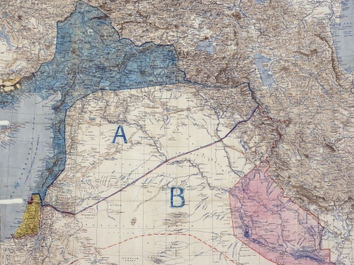
The Sykes-Picot line, separating Syria and Iraq. Image: Royal Geographical Society/Wikimedia

This article was originally published by the Foreign Policy Research Institute (FPRI) on 23 July, 2015.

Events in the Middle East seem to make some commentators and officials forget the fact that borders matter—everywhere, including the Middle East.  Most borders reflect the vagaries and irrationalities of history.  Sometimes they look arbitrary—history does not usually produce straight lines.  Borders frame states, and states are the constituents of the international system and order.  Borders bound sovereignty.  Their recognition implies acceptance of power within boundaries.  For these reasons alone, governments and commentators should take them seriously and be wary of too-easy calls to change them.  Just look at the Balkan bloodbaths of the last 150 years for examples other than those in Iraq and Syria of what can happen when borders are torn up or control of borders becomes a politico-military issue.  In short, borders are at the heart of international peace, order, and prosperity.

Categories
Terrorism

‘You Have to Neutralise Terrorists through Terrorists’: Is There a Method to This Madness?

Defense Minister Manohar Parrikar addresses the media during the Naval Commanders’ Conference 2015. Image: Indian Navy/Wikimedia

This article was originally published by Strife on 2 June 2015.

While attending a function in New Delhi On May 21st, India’s Defence Minister Manohar Parrikar said ‘You have to neutralise terrorists through terrorists’. He was referring to the threats to Indian national security from an alleged Pakistan sponsored proxy war. It was a profound statement, as it came from a defence minister of a right-wing nationalist government that came into power with an absolute majority riding on the election promises of giving a befitting reply to provocations originating in Pakistan.

Stormy Waters? The Maritime Border Disputes between Bolivia, Chile and Peru

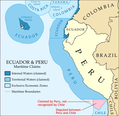
Map of the maritime claims of Ecuador, Peru, and surrounding countries. Source: Political Geography Now via Wikimedia Commons

International boundaries are often blurred by the processes of globalization, but in South America some maritime borders remain contested. For instance, Chile and Peru, neighbors that have enjoyed sustained economic development over the past few years, remain at odds over approximately 38,000 square kilometers of sea located along their maritime border.

Bilateral negotiations between the two countries were first held in 1980 but no agreement was reached. In 2008, Peru took the case to the International Court of Justice (ICJ) which, in turn, considered the issue at a public hearing in December 2012. The ICJ is expected to make a ruling on the dispute in mid-2013.

In the meantime, Peru continues to argue that the maritime border has not yet been defined by any agreement, with documents signed in the 1950s only relating to access to fishing grounds.  Lima also claims that maritime limits should run diagonally south-west from the land border.